HydroBeam M4 ile Dikey Kanyonlarda Hassas Batimetri
Proje Arka Planı
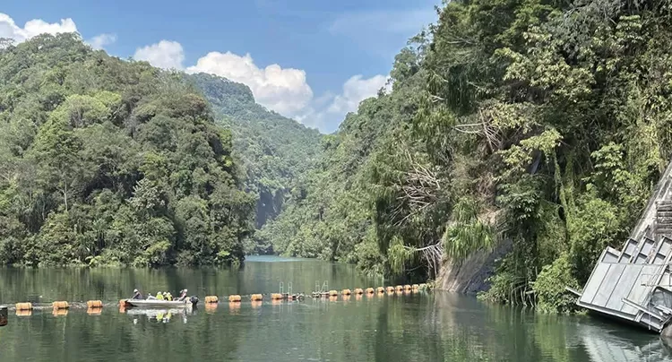
Dar bir nehir, dik ve neredeyse dikey kaya duvarlarının her iki yanında keskin bir şekilde yükseldiği etkileyici bir kanyonun içinden kıvrılarak akıyor. Su derinlikleri tahmin edilemez bir şekilde değişiyor; 1 metrelik sığ bölgelerden 20 metrelik derin havuzlara kadar uzanarak zorlu ve dinamik bir su altı manzarası oluşturuyor. Yerel hidroelektrik santrali için bu araziyi doğru bir şekilde anlamak sadece teknik bir görev değil, aynı zamanda operasyonel güvenlik açısından da kritik önem taşıyor. Geleneksel ölçme araçları, bu neredeyse dikey kanyon duvarları boyunca güvenilir ölçümler elde etmekte zorlanmakta, bu da verilerde boşluklara ve riskin artmasına yol açmaktadır.
Şekil 1: Hidroelektrik Santrali
Bu zorlukların üstesinden gelmek için proje ekibi, özellikle karmaşık ve dikey su altı arazilerinde yüksek hassasiyetli hidrografik araştırmalar için tasarlanmış HydroBeam M4 çok ışınlı yankı iskandilini kullanıma aldı.
Yüzeyin Altındaki Zorluklar
Bu tür bir kanyonun haritasını çıkarmak birçok engeli beraberinde getiriyor:
-
-
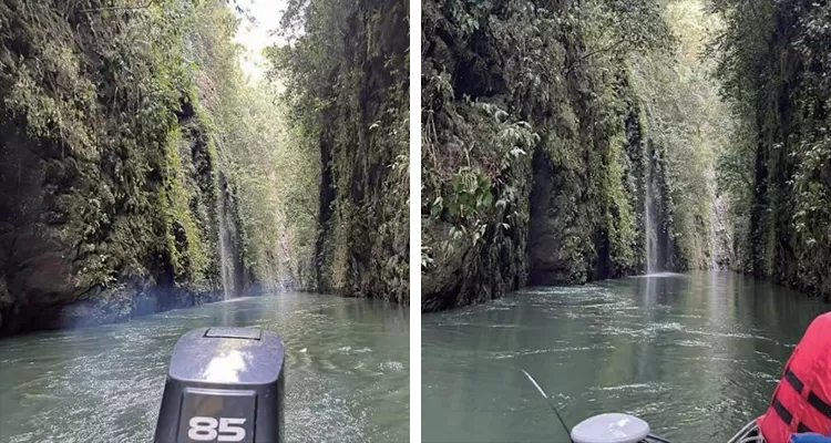
- Dar alanlar: nehrin bazı bölümlerinin genişliği 20 metreden azdır.
- Dikey duvarlar: Aşırı eğimler ışın bozulmasına ve öngörülemeyen akustik yansımalara neden olur.
- Değişken derinlikler: Sığ ve derin sular arasındaki hızlı geçişler, tutarlı ölçüm yapmayı zorlaştırır.
- Akustik anormallikler: Kanyon duvarları, nehir yatağı ve su yüzeyi arasındaki çoklu yansımalar gürültülü veya yanıltıcı veriler üretebilir.
-
Şekil 2: Nehir yatağının her iki tarafındaki dikey kaya duvarları
Çözümün Dağıtımı
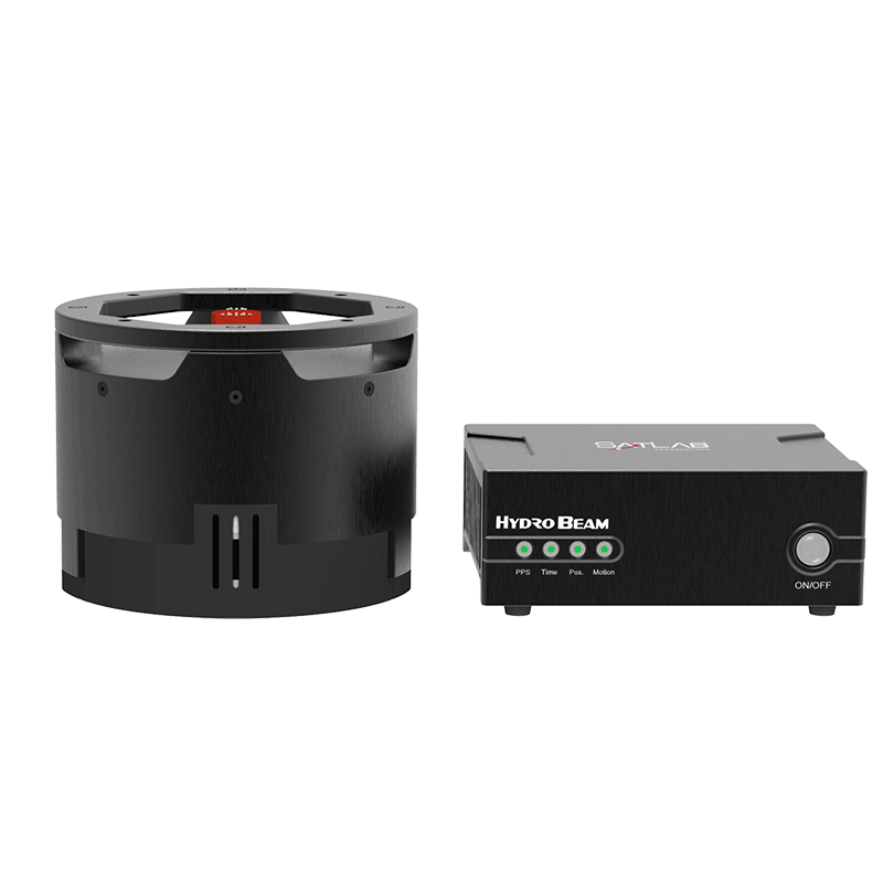
Şekil 3: HydroBeam M4 Çoklu Işınlı Yankı İskân Cihazı
Proje ekibi, bu zorlukların üstesinden gelmek için HydroBeam M4'ün gelişmiş yeteneklerine güvendi:
-
-
- Genişletilmiş yan duvar veri toplama için 150° tarama kapsamı
- 1024 ışın, yoğun ve yüksek çözünürlüklü batimetrik nokta bulutları sağlıyor.
- Dikey Arazi Algoritması, dik yamaçlarda ve dikey duvarlarda istikrarlı ölçümler sağlar.
- Entegre GNSS, IMU ve SVS, kurulumu basitleştirir ve hassas konumlandırma ve hareket telafisine olanak tanır.
-
Veri Toplama İş Akışı
1. Arazi Ölçüm Hattı Planlaması
-
-
- Tam kapsam sağlamak için ≥30% örtüşme oranına sahip paralel ölçüm hatları.
- Kalibrasyon ölçümleri, arazinin kilit noktalarından toplandı.
-
2. Saha Araştırması
-
- HydroBeam M4 ile donatılmış küçük insanlı araştırma gemisi
- Ses yayılımındaki farklılıkları düzeltmek için birden fazla konumda ses hızı profilleri ölçülmüştür.
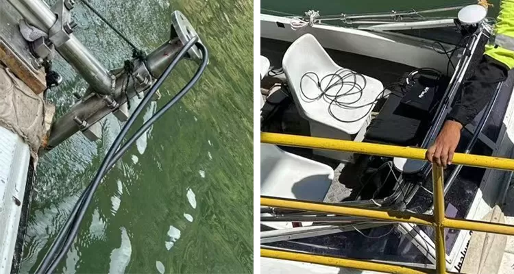
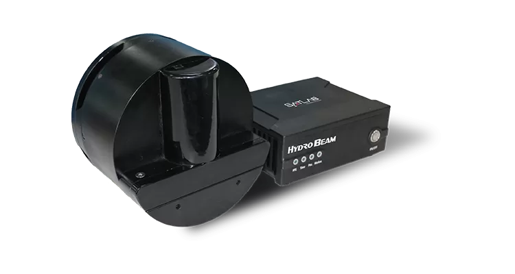
Şekil 4: Küçük İnsanlı Araştırma Gemisine Monte Edilmiş HydroBeam M4
3. Gerçek Zamanlı Veri Toplama
-
- HydroBeam Monitor yazılımı, istikrarlı veri sağlamak için sistem parametrelerini otomatik olarak ayarlar.
- SLHydro Survey yazılımı verileri toplar ve gerçek zamanlı görselleştirme sağlar.
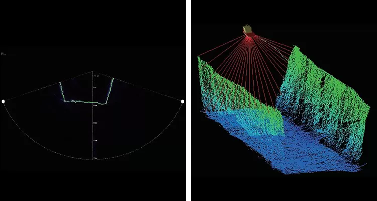
Şekil 5: Gerçek Zamanlı Veri Görselleştirme
Veri İşleme
Yazılım: Son işlem için SLHydro Survey kullanıldı.
-
-
- Veri Entegrasyonu: GNSS, IMU ve çok ışınlı ölçümler kalibrasyon parametreleriyle birleştirildi.
- Gürültü Filtreleme: Anormal veya hatalı derinlik noktalarının kaldırılması
- Çıktı: Mühendislik analizi için uygun yüksek çözünürlüklü 3 boyutlu su altı nokta bulutları, kontur haritaları ve kesit profilleri.
-
Şekil 6: Anket Verilerinin Son İşlemi
Teslimatlar
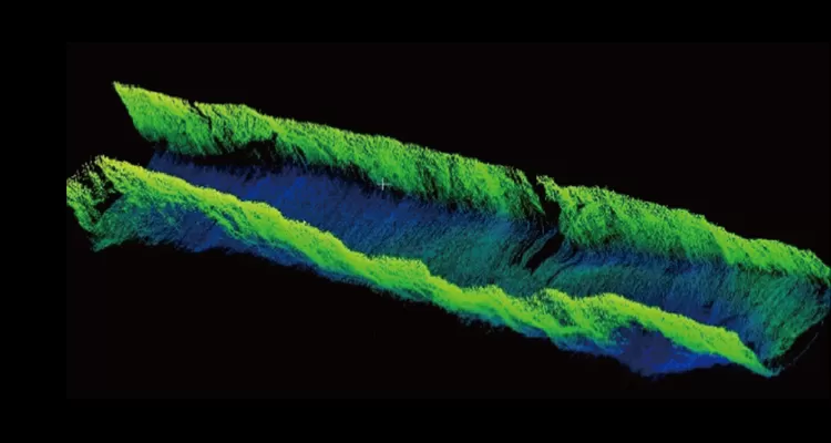
Şekil 7: 3 Boyutlu Sualtı Nokta Bulutu Görselleştirmesi
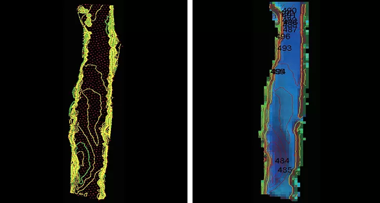
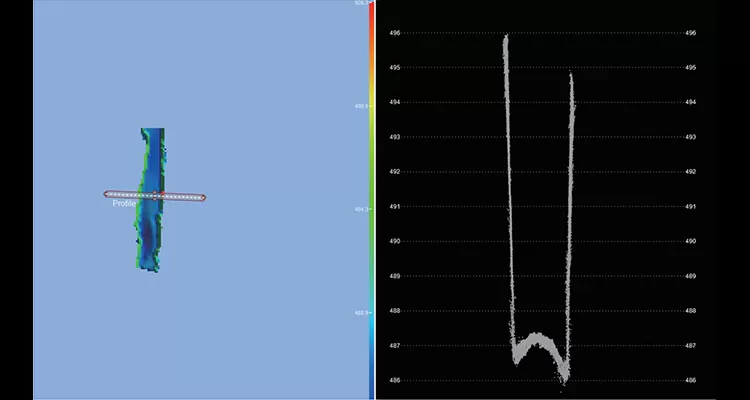
Şekil 8: Batimetrik Kontur Haritası
Kanyon araştırması, HydroBeam M4'ün zorlu dikey araziler için çığır açan bir çözüm olduğunu kanıtlıyor. Güvenilirlik ve hassasiyetle tam kapsamlı, yüksek çözünürlüklü batimetri sağlayan bu cihaz, mühendislerin ve operatörlerin güvenle karar vermelerini sağlarken, hidrografik ölçümde yeni bir standart belirliyor.
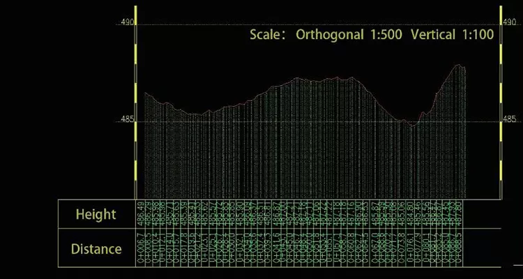
Şekil 9: Nehir Kesit Profili
Proje Sonucu
HydroBeam M4 çok ışınlı yankı iskandili, karmaşık bir dikey kanyon araştırmasını hassas, verimli ve güvenilir bir işleme dönüştürmeyi başardı. Yüksek çözünürlüklü, tam kapsamlı batimetri sağlamanın ötesinde, mühendislerin ve hidroelektrik santral operatörlerinin güvenle bilinçli kararlar almalarını sağlayarak, zorlu ortamlarda hidrografik ölçüm standartlarını yeniden tanımlıyor.